Climbing Mt. Garfield With My Brother (& Losing My Toenails…)
Towards the end of May I had talked about getting to climb Mt. Garfield with my little brother. The opportunity for a hike of this kind, and some true child-free adventuring, does not happen often these days, for either one of us.
It would be my first time, and my brother’s second, summiting Mt. Garfield. We were both looking forward to some adult-sibling-bonding time, spent in the Great Outdoors.
Getting Paid to Hike?!
So get a load of this: I got paid $500 to hike that day!
A few weeks prior, I stumbled across an outdoor blog post describing how Grape Nuts was looking for 60 people who were interested in getting paid to climb a mountain, as part of their Summit Sampler campaign. Sponsored to play outside? Where do I sign up for this again?
Turns out Sir Edmund Hillary had munched on Grape Nuts during his historical “first person confirmed to have reached the summit of Mt. Everest” climb, 60 years ago.
To celebrate, Grape Nuts decided to have some hikers hit the trail. You know, wearing bright purple t-shirts and handing out cereal samples. But hey, getting paid $500 to go hiking that day… I could handle passing out a few boxes at the trailhead. Nooo problemo.
Climbing Mt. Garfield in Western Colorado
If you’ve ever driven along I-80 in Western Colorado, chances are you’ve seen this trail near Palisade. Mt. Garfield is the rounded end cap to the Bookcliff Range. The trailhead parking lot can be easily seen form the interstate, and you may even spot a few clusters of hikers making their way up the bald spine of one of the Bookcliff ridges.

The trail to the top is only 2 miles long, but gains 2000′ feet in elevation. That’s a steep climb.
Not having done much serious hiking in recent years, I begin to question myself. Can I do this? Will my fear of heights kick in, and paralyze me – forcing my brother to give me a piggy back ride down, or worse… have to call a Rescue Helicopter for me?
Then we started coming across a few local college kids, in gym shorts, without even so much as a water bottle or a hiking boot between them. Turns out it’s a popular training trail for young athletes. Well, I’m not THAT over the hill… I can handle this. (But I still don’t agree with their “no water bottle approach”, I think that’s just plain foolhardy. Whippersnappers.)

That first spine stretch is fairly grueling. Actually, it’s not that bad… but you just want to start early to beat the heat. Most hikers seemed to stop and take short catch-your-breath breaks along this section. So it wasn’t too unpleasant, it just took a little time.
After you’ve got that behind you, the remainder of the hike is more interesting. Early on, you come across this abandoned mine entrance in the side of the mountain.
Now I wasn’t paying much attention to time, but I felt at this point I’d been doing a fair amount of strenuous hiking. I could feel it. And then we came across this. My personal take on it: Cruel goading, under the guise of being a helpful trail marker.

I shed a little tear.
But quickly rallied from this discouraging discovery, and pressed on to the next pretty landscape. Although a short two miles, this trail is surprisingly diverse.
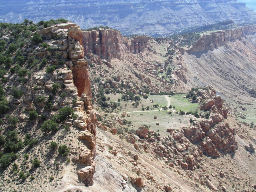
There are two different breaks in the ascent along the way, where it opens up to flat plateau areas which are really neat. Here is the first plateau we came across. Along the top of the Bookcliffs is a large area reserved as a wild horse refuge. We saw signs that the horses come down as far as these plateaus, but did not see any that day.

You get to take a little breather along these stretches, and it provides a welcome break from the otherwise constant incline.
Are you thinking, “She’s crazy. That’s not pretty… that’s ugly, dry desert.”? Well, it’s true that the high mountain desert landscape we have here is different than the typical evergreen laden Colorado Rockies. I’ve found for me it was an acquired taste, but now I really do think it’s beautiful!
Next up, a boulder field. There’s a pretty clear trail, though, and you do not need any particular rock climbing skills to get through. Trust me, cause I have none.
About now, the views looking back down into the valley from whence you came start looking mighty impressive.
And here comes another open plateau area, with some trees to spice things up a bit. By now, I was really loving this hike.
We’ve gained some altitude now, and all we’ve got left is that top crusty ridge.
There are many opportunities to absorb and appreciate the beauty of the desert along the way. We also saw about 118 lizards.
At this point, you have a breathtaking, perfectly framed view of Grand Mesa when you turn around and look back down the trail, from the direction you just climbed.
Wow. Ok, once again a fairly obnoxious reminder that you haven’t gone nearly as far as you thought you had.
We press on.
The next cliff hugging ridge is an exciting portion of the trail. I’m a big wuss about heights, and you are up fairly high at this point. As in, “plummet and/or skoot to your death and/or painful injury” high. But I still felt safe, this was very doable.
Now we’re kindof coming around from behind. There’s some mild bouldering you need to accomplish, over those rocks at the top, but then you’re in the zone.
Again, looking back behind us. This is the trail that takes you along the bottom of that last top crusty ridge, as you sneak around from behind to summit Mt. Garfield.
I thought this was interesting. Looks like powdered coal seeping out of a seam in Mt. Garfield, which is what I heard that abandoned mine used to harvest from this mountain.
At at last… we made it! The summit of Mt. Garfield is actually a large, flat area you can freely explore.


From the top of Mt. Garfield, you look down on the valley where the city of Grand Junction, CO, resides. Although this is natively a very dry area, the Colorado River runs through it, and is used to irrigate the numerous orchards and wineries found here.
Looking west, you are viewing the flat top of the Bookcliffs. On the far horizon there, you are seeing Utah – it’s about 20 miles away.
The money shot I sent to Grape Nuts, to claim my loot. The day I got paid to go hiking. A very good day.

So we made it to the top of Mt. Garfield! This is a fantastic hike that I’d recommend to anyone. At a moderate pace, round trip it takes an average of 3-4 hours.
The trip down is even more challenging than the climb up, in it’s own way. Lace those boots up tight! Some people complain of knee pain on the way down. Me? My toes were killing me!
I kept asking my brother, “Do your toes hurt?” Mine were ramming into the end of my boots, prying and deepening the bruising with every step. He’d reply, “No, not really”. Me, I was wincing with every step and limping semi-severely. Towards the last portion of the trail’s descent, after a good amount of this torture which by then had me side-stepping to reduce the agony, he pipes up, “Well, now I’m starting to feel it in my toes, a little bit.”
Incidentally, this was the only time during the hike where I was mildly annoyed by my brother.
Sure enough, I did enough damage that day to cause BOTH of my big toenails to turn purple and then completely fall off by summer’s end. Gah! So much for cute sandal wearing weather. But it was absolutely worth it.
I made some great memories with my brother, climbing Mt. Garfield that day!
*o* *o* *o*


Comments (2)
Elle
September 30, 2013 at 1:57 pm
Beautiful photos! I’m curious, did you count all those lizards or is it just a good guess? LOL! So nice you got to hike it with your brother and get paid for it!
COMtnMom
September 30, 2013 at 7:52 pm
Ha! Some people carry a pedometer, I carry a lizard click-counter. So that’s probably a very close number. Unless I saw one of those little suckers twice and didn’t recognize him the 2nd time…? 😉
We had a lot of fun. Thanks for swinging by, Elle!